Satellite technology has come a long way in recent years, allowing us to observe our planet from space in ways that were once thought impossible. These observations provide valuable insights for applications ranging from environmental monitoring to disaster management and urban planning. In this blog post, we will look at different types of satellite data, each with its own unique capabilities and applications.
Multispectral Imagery
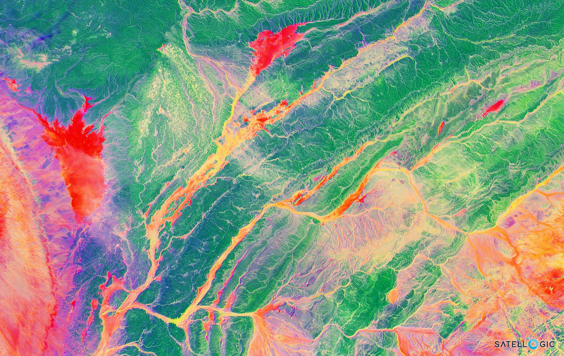
Multispectral imagery is one of the most common types of satellite data. It allows for the collection of data in multiple parts of the electromagnetic spectrum, extending beyond what the human eye can perceive. It is particularly valuable because it enables capturing rich information about the Earth's surface through various spectral bands. These bands can encompass visible, infrared, and thermal wavelengths, and each band serves a specific purpose in remote sensing and data analysis.
When it comes to providers of multispectral imagery, there are both open-source and commercial options. Open-source providers like the Copernicus Programme of the European Space Agency and USGS Earth Explorer offer extensive datasets that are accessible for free. On the other hand, commercial providers such as Airbus Defence and Space, Satellogic, and Planet Labs offer high-resolution and specialized multispectral imagery solutions for diverse industries.
The applications of multispectral imagery are diverse. It's used in agriculture to monitor crop health, detect diseases, and optimize irrigation. Environmental monitoring relies on it for tracking land cover changes and assessing the impact of climate change. In disaster management, it aids in assessing and responding to natural disasters like floods and wildfires. In urban planning, it supports development by providing insights into land use and infrastructure. For defense and security, governments use it for reconnaissance, border security, and military activity analysis.
Some of the technical aspects we should take into consideration for the selection of multispectral imagery are the following:
Wavelength Bands: Multispectral imagery captures data in multiple predetermined wavelength bands. These bands can include the visible spectrum (e.g., red, green, blue), near-infrared, and shortwave infrared.
Sensors: Multispectral data is typically collected using multispectral sensors onboard satellites, which are equipped with filters that isolate specific bands.
Resolution: The spatial resolution of multispectral imagery can vary depending on the satellite. High-resolution sensors provide finer details, while lower-resolution sensors cover broader areas.
Temporal Frequency: Some satellites offer regular revisits to the same location, allowing for temporal analysis of changes in Earth's surface.
Get multispectral satellite imagery
Find satellite imagery of up to 30cm spatial resolution and start saving time and money.
Hyperspectral Imagery
Satellite hyperspectral imagery represents a cutting-edge technology in the field of remote sensing. Unlike traditional satellite imagery, which captures data in a few broad spectral bands, hyperspectral imagery takes data collection to a whole new level. It does so by capturing data across a multitude of narrow, contiguous spectral bands in the electromagnetic spectrum.
These numerous narrow bands are like incredibly detailed slices of the electromagnetic spectrum, with each band capturing data in a very specific wavelength range. This high spectral resolution results in an extensive dataset with a wealth of spectral information. In practical terms, it's somewhat akin to having hundreds of finely tuned radio stations, each representing a different frequency within the electromagnetic spectrum.
The power of hyperspectral imagery lies in its ability to provide a remarkably fine level of spectral detail. This means it can discriminate between materials and substances on Earth's surface with exceptional precision. Each material, such as minerals, vegetation, water bodies, or man-made structures, has a unique spectral signature. These signatures are like the fingerprints of materials, and hyperspectral imagery allows us to identify and analyze these fingerprints. To this end, hyperspectral imagery is used for mineral exploration, agriculture, environmental monitoring, land use planning, and scientific research. It aids in mineral identification, crop health assessment, environmental change detection, urban planning, and scientific studies.
Before ordering hyperspectral imagery, consider technical specifications such as spectral resolution, spatial resolution, radiometric calibration, revisit frequency, and coverage area. These specifications should align with your specific application needs.
SAR Data (Synthetic Aperture Radar)
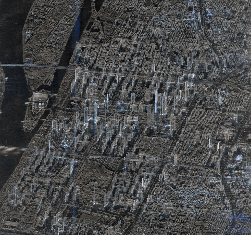
Synthetic Aperture Radar (SAR) is a remote sensing technology that uses radar to capture high-resolution images of the Earth's surface. Specifically, SAR employs radar waves to illuminate the Earth's surface and capture the backscattered signals. These signals are processed to create radar images. SAR is known for its all-weather capability, being insensitive to weather conditions, cloud cover, and daylight, making it highly reliable for continuous monitoring.
L-band and C-band are two common frequency bands used in Synthetic Aperture Radar (SAR) technology, and they each offer unique characteristics and advantages for remote sensing applications. The choice between L-band and C-band SAR depends on the specific requirements of the remote sensing application. L-band is favored for its penetration capabilities and suitability for vegetation and soil moisture monitoring, while C-band excels in providing high spatial resolution and is often used for applications requiring detailed surface features.
The versatility of SAR data lies in its capacity to offer a wealth of information beyond what the human eye can perceive. SAR data can be processed to generate various products, including terrain elevation models, vegetation health indices, land cover classifications, and even motion detection for monitoring subsidence or ground shifts. These capabilities make SAR an invaluable tool for a wide range of applications, from disaster response and environmental monitoring to agriculture, forestry, and infrastructure assessment.
Before ordering SAR data, consider factors such as spatial resolution, frequency band (C, L, or others), polarization (single, dual, or quad-polarization), revisit frequency, and coverage area. These specifications should align with your specific application needs.
TerraSAR-X satellite image of Shanghai Skyline. Source: Airbus Defence and Space
Nighttime Satellite Imagery
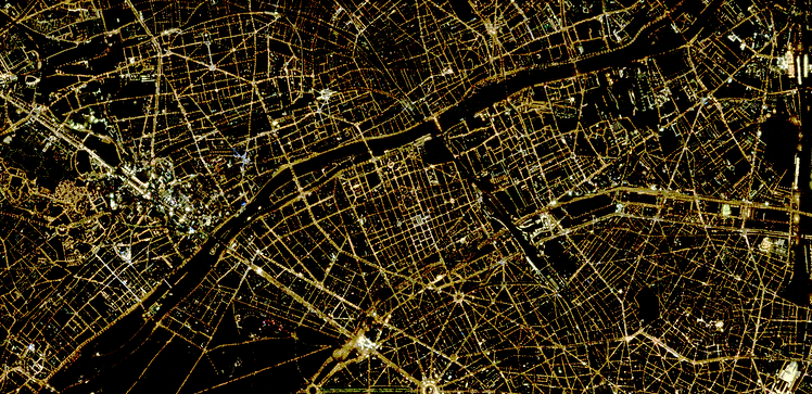
Nighttime satellite imagery refers to images captured by Earth-observing satellites during the night or under low-light conditions. These images depict the Earth's surface illuminated by artificial lights, primarily from urban areas, and sometimes natural sources like the moon and stars. Nighttime imagery provides insights into urbanization, human activity, and nighttime environmental changes, such as wildfires and volcanic eruptions.
When ordering nighttime satellite imagery, consider factors such as spatial resolution, temporal resolution, and radiometric calibration. Spatial resolution defines the level of detail in the image, while temporal resolution specifies the frequency of data collection. Radiometric calibration ensures the accuracy of radiance values in the imagery. These specifications should align with your specific application needs.
Satellite videos
Satellite videos represent a compelling and dynamic medium for understanding our planet's ever-changing surface. They are essentially sequences of images captured by Earth-observing satellites in orbit, stitched together to create a continuous, time-lapsed view of the Earth. These videos offer a vivid portrayal of the planet's evolution, showcasing a wide array of changes and events over time.
The value of satellite videos lies in their ability to capture a broad spectrum of terrestrial phenomena. From natural occurrences like seasonal changes, wildfires, and glacier movements to anthropogenic activities such as urban expansion, deforestation, and infrastructure development, these videos provide a comprehensive view of our planet's dynamic nature. The ability to observe these changes over time is invaluable for a wide range of applications.
Some of the satellite video technical aspects you should take into consideration before ordering are the frame rate, spatial resolution, video duration, and spectral resolution.
Conclusion
The array of satellite data types, including multispectral, hyperspectral, satellite videos, SAR imagery, and nighttime imagery, offers a comprehensive toolkit for understanding our planet. Each type provides unique insights into Earth's diverse features, environments, and changes, making them invaluable resources for various applications. From assessing land cover changes to monitoring urban growth, studying environmental shifts, and responding to disasters, these satellite data types empower researchers, decision-makers, and professionals across a spectrum of disciplines. By harnessing the power of these technologies, we gain the capacity to explore, analyze, and address the complex challenges facing our world.


